There were horrendous gale force winds making a howling noise most of the night. We were expecting to be called by the hotel during the night to say the boat had arrived, but no such luck.
In the morning, I went outside and took a photo of our hotel and also of the harbour without a ferry in sight!
We had breakfast and then I made the decision to call the hotel in Halifax and cancel our booking for tonight. It's a shame, as our two-day stay in Halifax will be cut short. We then all drove to see if the local Railway Heritage Museum was open, as we had seen they have an extremely rare Portuguese astrolabe, a 17th century navigational instrument that was recovered from a wreck in 1981.
Unfortunately it was closed, so we headed for the terminal to find out what was happening to our ferry. We were told that we had to check in as they were expecting the boat to dock in the next few hours.
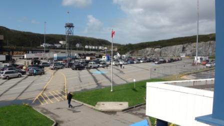
The ferry terminal with the trucks lined up waiting to load.
I went into the terminal and up to the observation deck to take this photo of the ferry still out at sea!! It had now been outside the harbour for over twenty hours.
The cars lined up ready for loading when the ferry finally arrives.
We waited for several hours and then suddenly there was an announcement that the Blue Puttees would be docking in ten minutes. We all rushed outside and watched as she did a 180 degree turn, struggling against the wind, and then reversed up to the loading ramps.
As I walked back to our car, I saw this ATV on a trailer. It made a good photo.
As I type this, I can see the cars and trucks unloading and, with any luck, we will be boarding by 6pm, at the latest. The wind is still gusting and I can only imagine what the crossing is going to be like. It's definitely time to take the seasickness pills we brought with us!!
This posting is being continued from our hotel room in North Sydney after our crossing from Channel-Port aux Basques. As soon as we boarded the ferry at around 7pm, we were told that when we arrived at around midnight in North Sydney, we would have to disembark as the ship was returning immediately to Port aux Basques. I was annoyed, to say the least, as we were hoping to stay in our reserved cabin until the morning.
We then discovered we had an inside cabin without a porthole, which was far from ideal and, try as we might, they wouldn't swap it for an outside cabin.
I went up on deck and took some photos of Channel-Port aux Basques as the ship steamed out of port. The wind had finally died down and it was a clear but chilly evening as we left Newfoundland after our stay of nearly a week. What fun it has been.
The sun was setting as we headed out into the Cabot Strait and the ship started to roll in the swell left behind by the storm that had been raging here for the past two days. It was a beautiful sight as I watched the sun slip below the horizon.
The journey took about four and a half hours and we reached North Sydney, Nova Scotia at around midnight. We disembarked and drove the short distance to our hotel, which we had managed to book on the ferry. We checked in and got to bed around 1am. We adjusted our watches by the half an hour difference between Newfoundland time and Atlantic time.
A three thousand eight hundred miles drive from St.John's, Newfoundland, down the Eastern Seaboard of North America, to Savannah, Georgia. The first week of the drive, from St.John's to Halifax, Nova Scotia, completes the coast to coast Canadian drive we started in May 2010, albeit driving in the opposite direction!
Rocky Harbour to Port aux Basques
Today was one of the highlights of the drive. We were visiting the Callaghan Trail in the Gros Morne National Park. The trail, to the top of Gros Morne Mountain, was dedicated to the British Prime Minister, James Callaghan. I was at school with his son, Michael, who told me about the trail when we mentioned we were visiting Newfoundland. Pierre Trudeau, the Canadian Prime Minster at the time, arranged for the trail to be named after Jim Callaghan in recognition of his environmental and peacekeeping efforts around the world. It was an extraordinary coincidence that the day we happened to be going to the trail was the 35th anniversary of the dedication, which took place in Ottawa on September 16th 1976.
On a miserable rainy morning, we drove from the hotel to the Park visitor centre where Wendy took this photo of Kenny with a friend of his!
We bought our entrance tickets and Wendy signed the visitors' book as follows:
It was a short drive to the trail, where we parked our cars and walked through the woods to the plaque commemorating the dedication to James Callaghan. It was a particularly beautiful spot with a short wooden bridge going over a fast running stream surrounded by dense woods.
The start of the trail.
The plaque in English and French.
The bridge on the trail near to the plaque and the stream rushing beneath it.
To prove we were there!
We carried on past the plaque for a short way up the hill and then turned back to the cars. The trail is a difficult hike to the top of Gros Morne Mountain and we weren't able to see the top as it was shrouded in clouds.
Our best view of Gros Morne.
We saw this plastic bag attached to a tree which described what a moose has to eat.
We returned to the cars and drove a few kilometres to Norris Point where we visited a 1920's "Saltbox" house maintained as a small museum.
A misty view of the inlet below Norris Point.
We returned to the hotel at Rocky Harbour, packed our bags and then left around noon for the 350 kms drive to Port aux Basques, where we were to catch the ferry to Nova Scotia. We drove back to the Trans-Canadian Highway at a place called Deer Lake.
Past Deer Lake, the weather improved and we had some wonderful views of Newfoundland scenery.
We reached the Cabot Strait, the channel between Newfoundland and Nova Scotia, and saw a very rough sea! We started to wonder if the ferry might be delayed.
We reached Port aux Basques and drove straight to the ferry terminal to find out what time we should check in. The ferry was scheduled to leave at 11.45pm and we were told to return at around 9.30pm. We drove down to the centre of the town and saw this bizarre mural which showed a car that had driven over a small child lying face down in the snow! We think the child was possibly playing on the snow, but who knows?
Port aux Basques Town Hall.
We reached the lighthouse at the entrance to the harbour and could see our ferry on the horizon, trying to come in.
As we had plenty of time before the ferry sailed, we drove out to a place called Isle aux Morts, so named because of the number of shipwrecks off the coast.
Bob saw a sign to a seafood restaurant, so off we drove down a side road to look for it for dinner. It was a great success - a small place serving wonderful fresh cod. As we were having our meal, we could see our ferry still waiting outside the harbour. It appeared that the wind was too strong for the boat to dock.
We drove back to the terminal and learned that the ferry was not going to be able to dock until the wind died down. The wind was now at gale force!! We waited in the terminal until nearly midnight, when we talked to an official of the ferry company, who suggested we book into a hotel and they would call us when the ship docked. So off we went to St. Christopher's Hotel, where we checked in and went to bed. As we did, we heard the wind rising to a howl outside. It seemed very unlikely we would be called in the night. We will just have to wait and see what happens.
On a miserable rainy morning, we drove from the hotel to the Park visitor centre where Wendy took this photo of Kenny with a friend of his!
We bought our entrance tickets and Wendy signed the visitors' book as follows:
It was a short drive to the trail, where we parked our cars and walked through the woods to the plaque commemorating the dedication to James Callaghan. It was a particularly beautiful spot with a short wooden bridge going over a fast running stream surrounded by dense woods.
The start of the trail.
The plaque in English and French.
The bridge on the trail near to the plaque and the stream rushing beneath it.
To prove we were there!
We carried on past the plaque for a short way up the hill and then turned back to the cars. The trail is a difficult hike to the top of Gros Morne Mountain and we weren't able to see the top as it was shrouded in clouds.
Our best view of Gros Morne.
We saw this plastic bag attached to a tree which described what a moose has to eat.
We returned to the cars and drove a few kilometres to Norris Point where we visited a 1920's "Saltbox" house maintained as a small museum.
A misty view of the inlet below Norris Point.
We returned to the hotel at Rocky Harbour, packed our bags and then left around noon for the 350 kms drive to Port aux Basques, where we were to catch the ferry to Nova Scotia. We drove back to the Trans-Canadian Highway at a place called Deer Lake.
Past Deer Lake, the weather improved and we had some wonderful views of Newfoundland scenery.
We reached the Cabot Strait, the channel between Newfoundland and Nova Scotia, and saw a very rough sea! We started to wonder if the ferry might be delayed.
We reached Port aux Basques and drove straight to the ferry terminal to find out what time we should check in. The ferry was scheduled to leave at 11.45pm and we were told to return at around 9.30pm. We drove down to the centre of the town and saw this bizarre mural which showed a car that had driven over a small child lying face down in the snow! We think the child was possibly playing on the snow, but who knows?
Port aux Basques Town Hall.
We reached the lighthouse at the entrance to the harbour and could see our ferry on the horizon, trying to come in.
As we had plenty of time before the ferry sailed, we drove out to a place called Isle aux Morts, so named because of the number of shipwrecks off the coast.
Bob saw a sign to a seafood restaurant, so off we drove down a side road to look for it for dinner. It was a great success - a small place serving wonderful fresh cod. As we were having our meal, we could see our ferry still waiting outside the harbour. It appeared that the wind was too strong for the boat to dock.
We drove back to the terminal and learned that the ferry was not going to be able to dock until the wind died down. The wind was now at gale force!! We waited in the terminal until nearly midnight, when we talked to an official of the ferry company, who suggested we book into a hotel and they would call us when the ship docked. So off we went to St. Christopher's Hotel, where we checked in and went to bed. As we did, we heard the wind rising to a howl outside. It seemed very unlikely we would be called in the night. We will just have to wait and see what happens.
Twillingate to Rocky Harbour
We woke to a beautiful sunny morning and, when I looked out of our window, I saw that the iceberg we had taken photos of yesterday afternoon had drifted into shore and was now a fraction of the size. I was amazed how quickly it had melted and broken up.
I quickly dressed and walked up to the headland to see if any more icebergs were approaching the island. As I looked north I could see many more in the distance. With my zoom lens I snapped this photo of two bergs. The one on the horizon was massive.
As I walked back, I passed a rock named Queen Victoria because of its likeness to her profile. It made a great photo with the icebergs in the distance.
When I got back to the house our breakfast cook, Queen, had arrived and she proceeded to cook us a wonderful breakfast. Boiled eggs, fantastic home-made bread and incredibly tasty baked oatmeal with apple sauce on top! We 'persuaded' her to have her photo taken with Wendy, Bob and Kenny.
We packed our bags and decided to drive to the lighthouse nearby. We had wonderful views looking down on the sea and to the south we saw a huge tabular berg that was stuck fast on the seabed close to the causeway that leads to Twillingate Island.
As we were about to leave the lighthouse, we met a local man, Lloyd, who made TV documentaries about the island and we all bought some of his DVD's.
It was now nearly 10.30am and we had another 400 kms drive to reach our next stop in Rocky Harbour, so we drove away from the lighthouse into Twillingate. As we went through the centre of the town, we saw this iceberg and others that were very close to the shore.
We drove the 100 kms back to Highway 1 and then headed more or less due west. We stopped at an inlet for a short break after about two hours and then drove the remaining 200 kms to Rocky Harbour and our hotel, the Ocean View. Rocky Harbour is on the edge of the Gros Morne National Park, which we are intending to visit tomorrow to see the James Callaghan Trail. I'll explain more in my next posting.
I promised a photo of my latest sticker for the route that is now fixed to both front wings of the Landcruiser, so here it is.
Finally, we have just heard that a tropical storm is going to hit St. John's tomorrow and Saturday, with high winds and torrential rain. We just have to hope that our sailing to Nova Scotia tomorrow night is not affected.
I quickly dressed and walked up to the headland to see if any more icebergs were approaching the island. As I looked north I could see many more in the distance. With my zoom lens I snapped this photo of two bergs. The one on the horizon was massive.
As I walked back, I passed a rock named Queen Victoria because of its likeness to her profile. It made a great photo with the icebergs in the distance.
When I got back to the house our breakfast cook, Queen, had arrived and she proceeded to cook us a wonderful breakfast. Boiled eggs, fantastic home-made bread and incredibly tasty baked oatmeal with apple sauce on top! We 'persuaded' her to have her photo taken with Wendy, Bob and Kenny.
We packed our bags and decided to drive to the lighthouse nearby. We had wonderful views looking down on the sea and to the south we saw a huge tabular berg that was stuck fast on the seabed close to the causeway that leads to Twillingate Island.
As we were about to leave the lighthouse, we met a local man, Lloyd, who made TV documentaries about the island and we all bought some of his DVD's.
It was now nearly 10.30am and we had another 400 kms drive to reach our next stop in Rocky Harbour, so we drove away from the lighthouse into Twillingate. As we went through the centre of the town, we saw this iceberg and others that were very close to the shore.
We drove the 100 kms back to Highway 1 and then headed more or less due west. We stopped at an inlet for a short break after about two hours and then drove the remaining 200 kms to Rocky Harbour and our hotel, the Ocean View. Rocky Harbour is on the edge of the Gros Morne National Park, which we are intending to visit tomorrow to see the James Callaghan Trail. I'll explain more in my next posting.
I promised a photo of my latest sticker for the route that is now fixed to both front wings of the Landcruiser, so here it is.
Finally, we have just heard that a tropical storm is going to hit St. John's tomorrow and Saturday, with high winds and torrential rain. We just have to hope that our sailing to Nova Scotia tomorrow night is not affected.
St. John's to Twillingate
At long last, our Canadian/USA drive was about to begin. We woke early and when we looked out of our window, we saw the next huge cruise ship entering St. John's. This ship was called the Jewel of the Seas.
We had a quick breakfast and then packed the car. As we were taking Kenny and DeeAnne, we had to make sure we packed everything into the cage in the rear of the car to make room for them as our passengers. I was quite surprised we managed to squeeze all our bags in!
With Bob following us, we drove round to Kenny's hotel and collected them both. They put all their luggage into Bob's car. Once it was all packed away, we set off on the 430 kms drive to Twillingate.
We drove the same road, Highway 1, that we had been along yesterday to collect the cars. After 90 kms, we passed the turn-off to Argentia and continued north on the TCH. The road was quite empty and it was perfect driving as we made good progress towards the only large town on the route, Gander. The weather was fine until we hit some dense fog which slowed us up considerably. The fog continued for about half an hour and then we were back into good sunny weather with a temperature of around 22 degrees.
Much of the route was incredibly straight and you could see the road for miles ahead..
We reached the outskirts of Gander at around 1pm. As we neared the town and its international airport, we saw a sign to the Silent Witness Memorial. Knowing nothing about this, we turned off the road and went down a track to the site of the memorial.
In December 1985, a US plane carrying military personnel from the 101st Airborne Division, returning from peacekeeping duties in Sinai, Egypt, crashed on take-off from Gander airport, killing everyone on board. The plane failed to gain altitude and crashed on the hillside at the end of the runway. It was a very moving experience to see the statue of the single soldier holding the hands of a small boy and girl, symbolising the peacekeeping the servicemen had been involved in.
The four flags of Canada, the US, Newfoundland and the 101st Airborne Division.
We left the memorial and drove down the track to the shores of Gander Lake, a very beautiful place, especially in the bright sunshine.
We left Gander and drove the remaining 100 kms to Twillingate. As we approached the town, we crossed a causeway and at the entrance to the inlet we could see our first iceberg!
We drove a further 10 kms to our B&B to learn that it was full, but we were being given a holiday home instead. It was ten minutes away in a small community called Crow Head. The house overlooks the sea and just a short distance from the shore was a large iceberg!
We unpacked and walked up to the headland to look at the iceberg and then saw many more that were stranded in the shallow waters.
Wendy and DeeAnne walking up to the headland.
The view back to Crow Head.
A group photo taken by me.
The iceberg just visible around the rocky headland.
Another group photo, this time taken by Wendy. You can just see a large lump of ice between me and Thelma that someone had carried up from the beach and placed on the rail of the barrier.
We ended the day by having a good meal at a local restaurant. Tomorrow we drive across the island to the western coast, where we will stay just outside the Gros Morne National Park.
Postscript
Kenny has just Googled the US Airborne Division disaster and we learned that there was a split decision by the Canadian investigation authorities. The majority of members concluded it was due to icing on the wings or mechanical failure, whilst a minority said it was a mid-air explosion. The plane was carrying special forces personnel as well as ammunition and there was also the suggestion that a bomb might have been placed on the plane in Egypt.
We had a quick breakfast and then packed the car. As we were taking Kenny and DeeAnne, we had to make sure we packed everything into the cage in the rear of the car to make room for them as our passengers. I was quite surprised we managed to squeeze all our bags in!
With Bob following us, we drove round to Kenny's hotel and collected them both. They put all their luggage into Bob's car. Once it was all packed away, we set off on the 430 kms drive to Twillingate.
We drove the same road, Highway 1, that we had been along yesterday to collect the cars. After 90 kms, we passed the turn-off to Argentia and continued north on the TCH. The road was quite empty and it was perfect driving as we made good progress towards the only large town on the route, Gander. The weather was fine until we hit some dense fog which slowed us up considerably. The fog continued for about half an hour and then we were back into good sunny weather with a temperature of around 22 degrees.
Much of the route was incredibly straight and you could see the road for miles ahead..
We reached the outskirts of Gander at around 1pm. As we neared the town and its international airport, we saw a sign to the Silent Witness Memorial. Knowing nothing about this, we turned off the road and went down a track to the site of the memorial.
In December 1985, a US plane carrying military personnel from the 101st Airborne Division, returning from peacekeeping duties in Sinai, Egypt, crashed on take-off from Gander airport, killing everyone on board. The plane failed to gain altitude and crashed on the hillside at the end of the runway. It was a very moving experience to see the statue of the single soldier holding the hands of a small boy and girl, symbolising the peacekeeping the servicemen had been involved in.
The four flags of Canada, the US, Newfoundland and the 101st Airborne Division.
We left the memorial and drove down the track to the shores of Gander Lake, a very beautiful place, especially in the bright sunshine.
We left Gander and drove the remaining 100 kms to Twillingate. As we approached the town, we crossed a causeway and at the entrance to the inlet we could see our first iceberg!
We drove a further 10 kms to our B&B to learn that it was full, but we were being given a holiday home instead. It was ten minutes away in a small community called Crow Head. The house overlooks the sea and just a short distance from the shore was a large iceberg!
We unpacked and walked up to the headland to look at the iceberg and then saw many more that were stranded in the shallow waters.
Wendy and DeeAnne walking up to the headland.
The view back to Crow Head.
A group photo taken by me.
The iceberg just visible around the rocky headland.
Another group photo, this time taken by Wendy. You can just see a large lump of ice between me and Thelma that someone had carried up from the beach and placed on the rail of the barrier.
We ended the day by having a good meal at a local restaurant. Tomorrow we drive across the island to the western coast, where we will stay just outside the Gros Morne National Park.
Postscript
Kenny has just Googled the US Airborne Division disaster and we learned that there was a split decision by the Canadian investigation authorities. The majority of members concluded it was due to icing on the wings or mechanical failure, whilst a minority said it was a mid-air explosion. The plane was carrying special forces personnel as well as ammunition and there was also the suggestion that a bomb might have been placed on the plane in Egypt.
Subscribe to:
Posts (Atom)